
 money
money Tornadoes possible Wednesday as severe storms aim for Mississippi Valley


The risk of severe weather will ramp up across the south-central United States into Wednesday evening as a potent storm system pivots from the Rockies to the Mississippi Valley. AccuWeather meteorologists warn that the full spectrum of severe weather is likely with this storm system, including the potential for tornadoes in areas that have already been hit hard multiple times this winter.
"A southward dip in the jet stream will strengthen as it swings into the lower Mississippi Valley on Wednesday," AccuWeather Chief On-Air Meteorologist Bernie Rayno said. "As this happens, stiffening southerly winds will grab Gulf of Mexico moisture and give thunderstorms a boost during the afternoon and evening hours."
 |
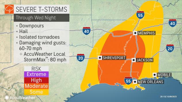
The main threat of severe weather will focus on the interstate 10, 20, 40 and 55 corridors that include Louisiana, Mississippi and southeastern Arkansas.
In Tangipahoa Parish, Louisiana, 60 miles east of Baton Rouge, a tornado-warned storm came over the area in the early evening, throwing debris into the air, as well as downing trees and power lines in the community.
Multiple reports of flash flooding came in Wednesday afternoon from the city of Jonesboro, Arkansas, located 70 miles northwest of Memphis, Tennessee:
@Region8News @ryanvaughan @WXAaronJC Video of the flooding pic.twitter.com/KCHWWocETU
— Keith Baggett (@keith1529) February 8, 2023
A moderate risk of severe weather and tornadoes includes the cities of New Orleans, Monroe and Alexandria, Louisiana, as well as Jackson and Vicksburg, Mississippi. Other major cities likely to experience severe weather include Shreveport, Louisiana; Little Rock, Arkansas; and Memphis.
Motorists, residents and visitors in the region may need to take action to find shelter during the storms, which are likely to be at peak strength from 4 p.m. to 10 p.m. Wednesday. The greatest risk of tornadoes will be during the late afternoon and early evening hours.
A tornado watch was issued by the National Weather Service for parts of Arkansas, Louisiana, Mississippi and Texas until 9 p.m. CST Wednesday. Another watch was issued until 11 p.m. CST Wednesday for cities such as Baton Rouge, Louisiana, and Jackson. AccuWeather National Reporter Bill Wadell noted that hail and heavy rainfall were already evident south of Jackson late Wednesday afternoon.
"The greatest potential for a strong tornado that may last more than a few minutes will be from discrete cells ahead of the main line of thunderstorms," Rayno said. These storms often have the strongest rotation and can tap into an unaltered plume of warm, moist air.
 |
As the severe thunderstorms organize into more of a solid line late Wednesday night, the risk of tornadoes will decrease, but incidents of damaging wind gusts may increase. However, there can still be a brief, isolated tornado that spins up in the advancing line of storms with torrential downpours and strong wind gusts across Mississippi, western Tennessee and Alabama.
In some cases, tornadoes may be concealed by heavy rain, low-hanging clouds or hilly, wooded terrain. The ability to seek shelter quickly will be especially important due to the risk of nocturnal tornadoes Wednesday.
"People need to know where to seek shelter prior to severe weather's arrival as every second counts," AccuWeather On-Air Meteorologist Geoff Cornish said. "Seek interior rooms in the lowest level of a home if there are no storm shelters nearby. If out in the open, a low-lying area or ditch may offer some protection."
One of the most significant severe weather and tornado outbreaks this winter occurred on Jan. 11-12, when well over 300 storm reports occurred, including more than 70 tornadoes over the south-central region.
Gulf of Mexico water temperatures of about 5-10 degrees above average have been a major player in the number of severe weather incidents, including the high amount of tornadoes and the ability for twisters to reach as far north as the central Plains and the Great Lakes region, AccuWeather Chief Meteorologist Jonathan Porter said.
"Usually severe weather is confined to areas along the immediate Gulf Coast during the winter months," Porter said.
 |
Since much of the jet stream energy associated with the storm will lift rapidly northward across the Great Lakes region Thursday, little severe weather, let alone much thunderstorm activity, is likely from the Appalachians to the southern Atlantic coast.
Heavy rain will bring a separate set of hazards to the region.
A soaking rain is in store from the northwestern and central Gulf coast through the lower Ohio Valley and into the mid-Mississippi Valley. A general 1-3 inches of rain is forecast, with locally higher amounts expected to approach 5 inches through Wednesday night.
 |
While the rain may help provide a small boost in Mississippi River levels, quick runoff could lead to flooding problems. The greatest threat from flooding will be along small streams and in urban areas with poor drainage, forecasters say. However, some of the secondary rivers in the region could experience a significant rise in water levels.
Many of the secondary rivers from Louisiana and Arkansas to Mississippi and Alabama were hovering at minor flood levels on Wedesday. Some points along the Big Black River and Pearl River in Mississippi were at moderate flood stage.
Want next-level safety, ad-free? Unlock advanced, hyperlocal severe weather alerts when you subscribe to Premium+ on the AccuWeather app. AccuWeather Alerts™ are prompted by our expert meteorologists who monitor and analyze dangerous weather risks 24/7 to keep you and your family safer.
