
 money
money Gati rapidly strengthens before making landfall over Somalia


Tropical activity is ramping up across the northern Indian Ocean with the development of Gati in the Arabian Sea. More development may be on the horizon as a disturbance continues to organize in the Bay of Bengal.
The first system to form in the basin this week was Gati. This system first developed into an area of low pressure on Thursday, according to India's Meteorological Department (IMD). By early Sunday morning, local time, the system strengthened into a depression. Just a few hours later, the system became a deep depression and then strengthened even further into Cyclonic Storm Gati. Development of this system exploded on Sunday and around 12 hours after first becoming a depression, Gati was a severe cyclonic storm.
 |
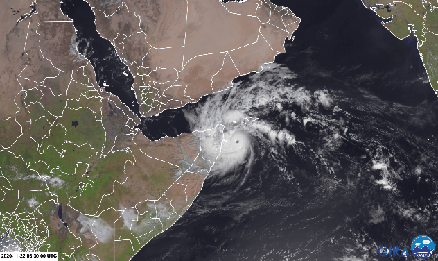
Severe Cyclonic Storm Gati has a clearly defined eye based on satellite imagery as it approaches the coast of Somalia late Sunday afternoon, local time. (RAMMB/CIRA) |
At around 6:00 p.m., local time, on Sunday, Gati made landfall over Cape Hafun, the easternmost point in Africa, as a very severe cyclonic storm. The storm had wind speeds around 130-140 km/h (80-87 mph) based on 3-minute average wind speed measurements by IMD, making it about equivalent to a Category 2 hurricane in the Atlantic and East Pacific tropical basins.
Meteorologists say this system was able to strengthen so rapidly because it is located in an area of warm water and low wind shear.
Ocean temperatures and wind shear, or the change in wind speed at different levels in the atmosphere, are two factors that help determine whether a tropical system will develop, gain additional strength or fall apart.
 |
Now that this storm is moving over land the window for additional strengthening is closing. While the storm is expected to gradually lose wind intensity through the beginning of the week, it can still bring dangerous impacts to the region.
AccuWeather Lead International Meteorologist Jason Nicholls warns that wind gusts of 145 km/h (90 mph) are expected near the center of the storm into Sunday night, local time, as continues to move inland.
Nicholls added, "widespread wind gusts of 96-129 km/h (60-80 mph) are possible across northern Somalia into Monday."
Winds of this magnitude could lead to damage to trees and structures. Strong winds can also churn up large waves across the northwestern Arabian Sea and Gulf of Aden, creating hazardous boating conditions.
CLICK HERE FOR THE FREE ACCUWEATHER APP
The heaviest rainfall will follow the track of the center of the storm as it tracks across northern Somalia, and can reach 75-150 mm (3-6 inches) across the northeast corner of the country into Tuesday. An AccuWeather Local StormMax™ of 250 mm (10 inches) will be possible in the heaviest downpours.
Some of the outer rain bands from Gati can reach as far north as Yemen and bring similar rainfall totals in addition to gusty winds into the beginning of the week.
Flash flooding will grow increasingly likely, especially in low-lying and poor drainage locations, through the beginning of the week as Gati tracks across the region.
Areas of tropical downpours can continue into Tuesday, and perhaps even Wednesday, across parts of Somalia, Ethiopia, Djibouti and Yemen as Gati gradually dissipates over the area.
This may not be the only tropical system to develop in the northern Indian Ocean by early this week as AccuWeather forecasters are also watching the Bay of Bengal.
 |
A well-marked low has developed over the southern Bay of Bengal and is on the verge of strengthening into a tropical depression, as of Sunday night, local time.
Decreasing wind shear over the Bay of Bengal can create an environment more conducive for tropical development, which could allow for additional strengthening through the beginning of the week.
"This storm can become Cyclonic Storm Nivar before making landfall over southern India around Wednesday," stated Nicholls. "Landfall is forecast to occur along the Tamil Nadu and Puducherry coasts between Karaikal and Mahabalipuram."
Depending on the exact strength of the storm it can bring damaging wind gusts near where it makes landfall.
 |
Nicholls cautions that although strong winds can lead to some localized damage near landfall, the main threat over Tamil Nadu, Puducherry and into southern Andhra Pradesh will be heavy rainfall and flooding from Tuesday night into Friday, local time.
Conditions may remain favorable for tropical development across the Bay of Bengal into early December.
Tropical activity usually picks up this time of year in the northern Indian Ocean once the Southwest monsoon weather pattern recedes. The Southwest monsoon typically occurs from June to October and is responsible for bringing wet weather to India throughout the summer.
Keep checking back on AccuWeather.com and stay tuned to the AccuWeather Network on DirecTV, Frontier and Verizon Fios.
