Hurricane watch issued for much of Florida's east coast, including Palm Beach County

UPDATE 10 a.m.: A hurricane watch has been issued for the east coast of Florida from the Volusia / Brevard County line through Hallandale Beach, including Palm Beach County.
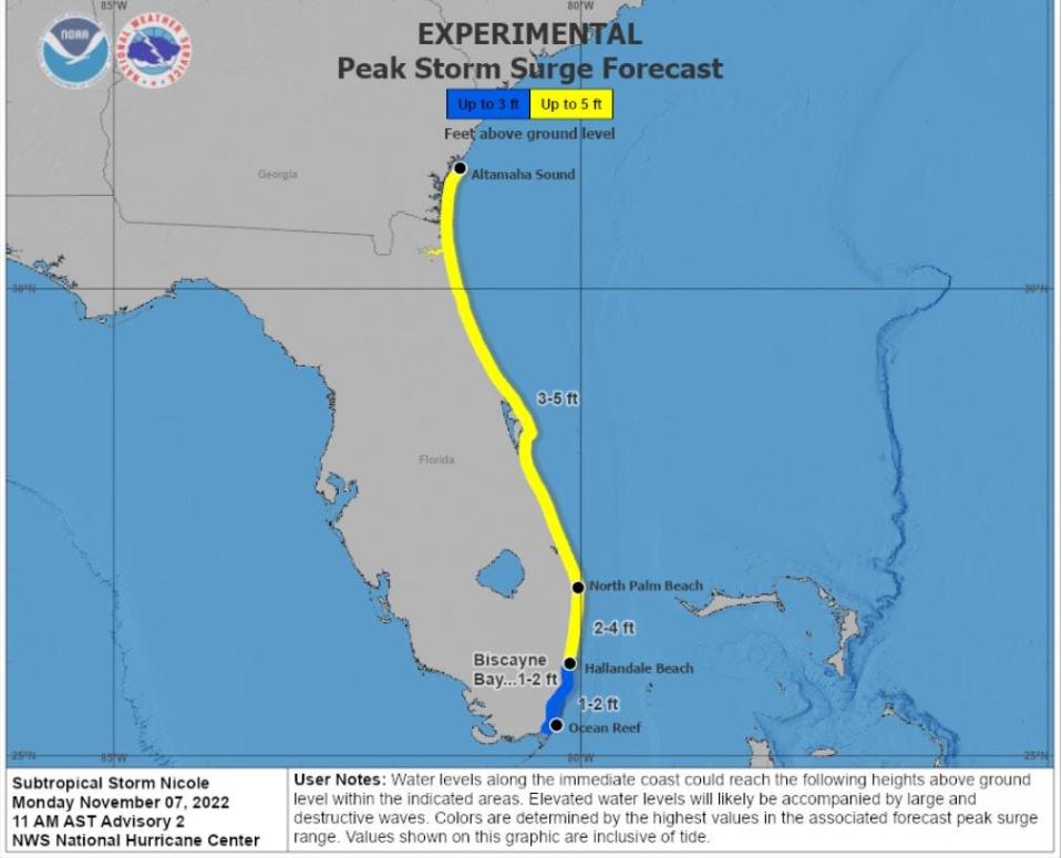
A storm surge watch has also been issue for areas from southern Georgia through Hallandale Beach. Storm surge for Palm Beach County is forecast to reach 2 to 4 feet with heights increasing to 3 to 5 feet in the Space Coast.
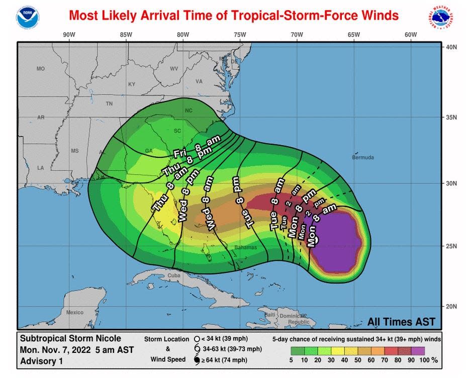
A hurricane watch is issued 48 hours ahead of the onset of tropical storm-force winds.
Previous story:
Areas of the east coast of Florida could be issued hurricane or tropical storm watches or warnings as early as Monday with an unusual late-season system taking aim at the Sunshine State.
The National Hurricane Center said the system, elevated to Subtropical Storm Nicole overnight, could be near or at hurricane strength approaching the northwestern Bahamas and the east coast of Florida on Wednesday and Thursday.
An official forecast issued early Monday has Nicole reaching sustained 75 mph winds before reaching Palm Beach County's coast with 90 mph gusts. Huricane watches are in effect for the northwestern Bahamas.
Track Nicole's path: See spaghetti models, path and storm activity for Florida
Storm insurance tips: Hurricane Ian is gone. Before the next storm, here are tips on how to review your insurance policy
Election Day outlook: Rare November tropical system could leave Election Day squally.

Weather conditions are expected to begin deteriorating Tuesday with coastal flooding and gusty winds from Jacksonville to Miami. A combination of heavy rainfall, high winds, offshore seas of up to 25 feet and a tide swollen by November's full moon will exacerbate flooding.
“Hurricane season is apparently not done with us yet,” said Michael Brennan, acting deputy director of the NHC, in a briefing Sunday. “The point I want to emphasize is the scale of the system is very large and we will see impacts over a large area.”

As of 4 a.m. today, Nicole was 551 miles east of the northwestern Bahamas with 45 mph sustained winds. It was moving north-northwest at a speedy 14 mph. Winds of 40 mph or higher extend a yawning 275 miles from Nicole's center.
Hurricane hunters are scheduled to fly into the system Monday morning.
Brennan said “several scenarios” are possible. The system could move across the state and into the Gulf of Mexico, ride up the spine of the peninsula or stay off the east coast as it heads north.
“As we get through the next several days, that will come into better focus,” he said.
A larger, broader subtropical system would spread impacts well north of the center, with lesser impacts to the south.
Gov. Ron DeSantis directed the Florida Division of Emergency Management on Sunday to monitor the Atlantic weather disturbance and to warn Florida residents on the east coast of its potential impact on the state, according to the governor’s office.
FDEM Director Kevin Guthrie said his office is keeping close contact with the National Hurricane Center, the National Weather Service and all 67 county emergency management directors throughout the state for what federal weather forecasters call “98L.”
"As the Division continues to support communities in their recovery from Hurricane Ian, we are now closely monitoring 98L," said Guthrie in a statement. “It is critical for Floridians to review their disaster preparedness plans and follow all directions from local officials in anticipation of potential impacts.”
“Regardless of intensity or exact path of the system, Floridians are reminded to prepare for an increased risk of coastal flooding, heavy winds, rain, rip currents and beach erosion,” emergency management officials said. “Wind gusts can be expected as soon as Tuesday along Florida's East Coast.”
Two key forces are aligning to create the potential havoc in the western Atlantic Ocean. High pressure to the north and the sprawling area of low pressure to the south will grate against each other to send speeding winds at the coast for several days. That will create a large area of fetch for building waves that could reach heights at the coast of 12 to 15 feet from Palm Beach County through the Treasure Coast, according to the National Weather Service.
Then there’s whatever Invest 98L has planned.
Cassie Leahy, a National Weather Service meteorologist based in Melbourne, said forecast models have differed on whether the system would remain a sloppy mess or consolidate its strength into something more menacing.
“We are coming up on it being just a few days away now and it’s unusual to have this kind of uncertainty so close,” Leahy said. “The time frame and window for people to prepare is shrinking.”
Leahy noted that areas on the east coast hit hard by October’s Hurricane Ian, including Volusia County, could see more beach erosion, flooding and potential wind damage.
“These are communities that are sensitive already and now we’ll have higher high tides, large breaking waves and coastal flooding,” she said.
Water temperatures are more than warm enough to support a tropical cyclone at about 83 degrees, which is 1.8 degrees warmer than normal.
Despite the warm water, Weather Underground co-founder Jeff Masters said in his column for Yale Climate Connections that rapid intensification is not expected because the system will eventually run into moderate to high wind shear as it approaches Florida.
“Invest 98L will also be entering a region of increasingly dry air, and these two influences are likely to prevent rapid intensification of the storm,” said Masters, who co-authored his Sunday column with meteorologist Bob Henson.
Rapid intensification is when wind speeds increase by 35 mph in 24 hours or less.
“We want folks in the Bahamas and all along the east coast to have their hurricane plan in place,” Brennan said.
Hurricane season runs through Nov. 30.
But it is rare for a November storm to reach Florida.
The most recent tropical cyclone to reach Florida in November was Eta, which made landfall Nov. 8, 2020, as a tropical storm on Lower Matecumbe Key. It did a loop in the Gulf of Mexico and made a second Florida landfall four days later near Cedar Key. Probably more memorable was 1985's Hurricane Kate, which hit near Mexico Beach four days before Thanksgiving as a Category 2 storm.
The other November hurricane to hit Florida was the 1935 storm nicknamed the Yankee because of its unusual approach from the north. It was born near Bermuda, rode the underbelly of the Bermuda High toward the coast of the Carolinas, but was then picked up by the clockwise swoop of another high-pressure system that pushed it into Miami on Nov. 4 as a Category 2 hurricane.
Another notable November storm was 1998's Hurricane Mitch, which formed in late October in the western Caribbean. It grew to a monster Category 5 storm before hitting Honduras, then hooked around and cut across the Gulf of Mexico to make landfall near Naples as a tropical storm on Nov. 5. Mitch slogged across the Glades and left the state near Jupiter, flooding homes from Boynton Beach to Boca Raton with relentless rain.
Sergio Bustos, USA Today Network-Florida Enterprise/Politics Editor, contributed to this story.
This article originally appeared on Palm Beach Post: National Hurricane Center predicting Nicole to impact Florida

 money
money 