
 money
money Hurricane force gusts prompt extremely critical fire risk in California
Northern California is under an "extremely critical" fire weather risk from Sunday to Monday. Such conditions are very rare, but when the National Weather Service warns of this, the danger can not be understated.
The last time this designation was used back in September, over a million acres were torched in just a few days as whole towns burned to the ground in Oregon.
This will be the strongest wind event of the fall so far, and perhaps the strongest in years. Hurricane force wind gusts are expected to knock down trees and power lines, sparking power outages. If wildfires spark up, conditions may quickly become life-threatening.
Meanwhile, in Colorado, the two largest fires in state history are burning right now. That same front responsible for the dangerous conditions in California will bring much needed relief with heavy snow and bitter cold Sunday and Monday.
This is all being caused by a wicked cold front dropping south and west through the Rockies. The front is dumping over a foot of snow in Montana and plunging temperatures by 50 degrees as record shattering cold autumn air settles in.
On Sunday this front will reach the Sierra-Nevada mountains in California and trigger a Diablo downslope wind event, where strong, bone dry winds will spill down the mountains and rush westward towards Sacramento and San Francisco. Gusts will surpass hurricane force in the hills and canyons, with some gusts exceeding 80 mph later Sunday into Monday.
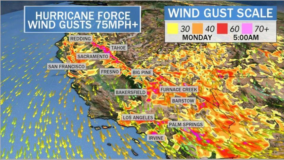
In Southern California, the winds crank up on Sunday, but the strongest gusts will be Monday as the Santa Ana winds kick up gusts over 60 mph.
Dangerous fire weather conditions are expected across parts of northern California from Sunday afternoon into Monday, as strong offshore flow develops across the region. pic.twitter.com/sWjzaEj0gF
— NWS Storm Prediction Center (@NWSSPC) October 24, 2020
Dangerous fire weather conditions are expected across parts of southern California, beginning late Sunday night and potentially lasting into Tuesday. High-end critical to locally extreme conditions are possible Monday into Monday night. pic.twitter.com/9r8iZWRWwg
— NWS Storm Prediction Center (@NWSSPC) October 24, 2020
PG&E is monitoring 38 counties for possible proactive power shutdowns to avoid power lines sparking new fires from Sunday into Monday. State officials are concerned that this fire season's unprecedented disastrous wildfires will either spark back up or new fires will ignite. With hurricane force wind gusts, fires can quickly burn out of control.
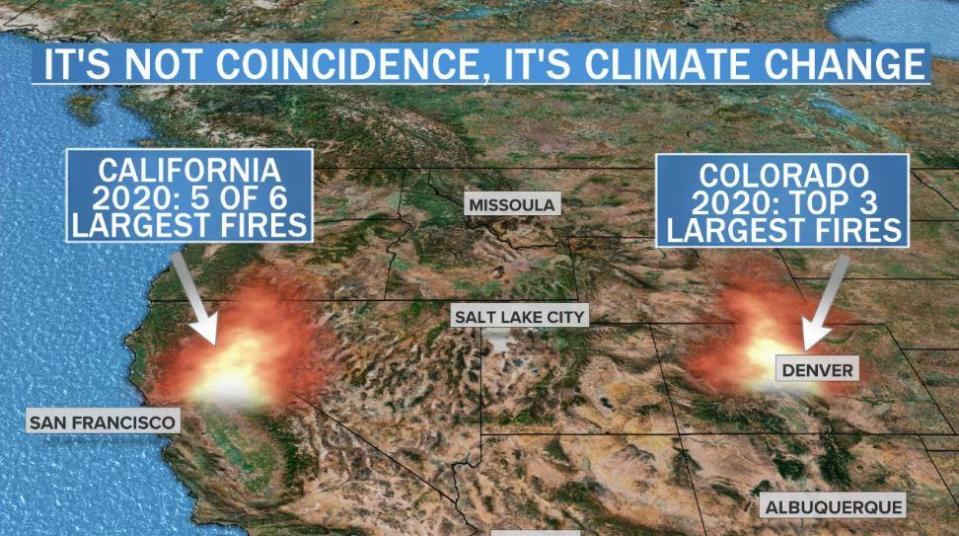
So far in 2020, California has experienced 5 out of its 6 largest fires in state history. In Colorado, the top three wildfires in the state's history have also burned in 2020. While excess brush, and in some cases human ignitions, are part of the equation, scientists say climate change has laid the groundwork for escalating fire weather, as warmer temperatures dry out forests.
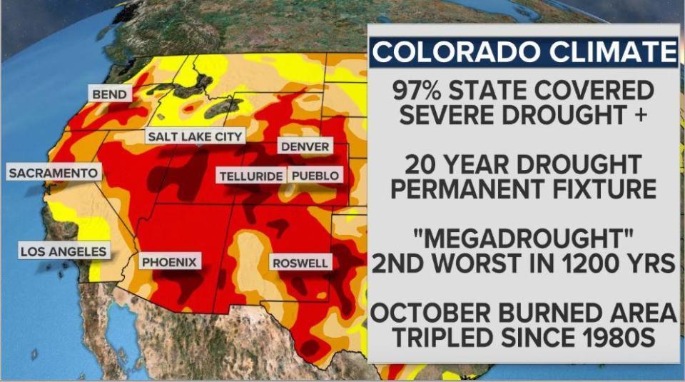
This year has been the second driest and the eighth warmest on record in the Southwestern States, exacerbating an already established 20-year drought across the West. Scientists say this Megadrought is one of the worst in 1200 years and more than 50% of the cause is warmer, drier conditions due to human-caused climate change.
But relief is on the way for weary firefighters in Colorado on Sunday. A heavy snowstorm is forecast for the state with some of the heaviest snow falling on mountainous areas where the fires are burning. By Monday, Denver and Boulder will see 6-12 inches of snow. West of the Front Range in the mountains, 1-2 feet of snow will pile up. Around 6 inches of snow will fall over the central Plain States.
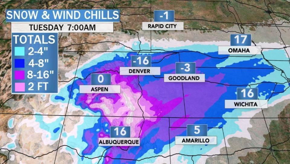
By Monday morning, widespread record cold temperatures will be shattered from the Rockies into the Plains. Temperatures will be 30-40 degrees below normal with lows in the single numbers and teens. Wind chills will be below zero for some. That very cold air will linger into Tuesday and Wednesday. In total, 150 record lows may be broken.
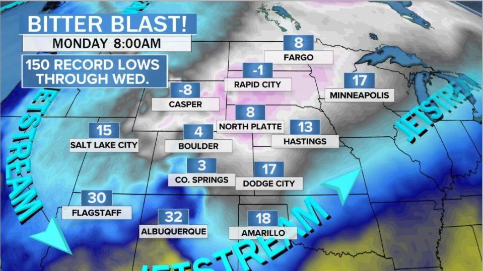
Snow and ice will fall as far south as northwest Texas and Oklahoma from Monday into Tuesday.
And as another sign of how volatile autumn can be, a tropical storm is brewing in the Caribbean. This storm is forecast to move north into the Gulf of Mexico as Zeta, perhaps making landfall along the northern Gulf Coast on Wednesday. All this while bitter cold and snow rages out West.
The latest models on TD 28, soon to likely be #Zeta. Storm may reach hurricane status early week, then probably weaken a little before landfall midweek as wind shear increases. The weary Gulf Coast looks to be the target - again! pic.twitter.com/mx6jI9MhyK
— Jeff Berardelli (@WeatherProf) October 25, 2020
Joe Biden: The 60 Minutes 2020 Election Interview
