
 money
money AccuWeather meteorologists warn of icy travel, power outages from Texas to Tennessee


AccuWeather meteorologists say that swaths of icy weather will continue for parts of the southern Plains and into the Ohio Valley, an area of the country recently hit by wintry conditions.
A busy weather pattern is expected to unfold this week with as many as three different storms traveling from the Rockies to the East coast. Rounds of rain will threaten to cause flooding for some in the South, but some others could instead see ice and snow.
"A wave of cold air pushing southward across the center of the country will make wintry precipitation possible from Texas to Kentucky and Tennessee," said AccuWeather Senior Meteorologist Bill Deger.
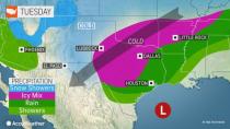
Winter storm warnings and ice storm warnings were in place for a large portion of Texas as well as a part of southeastern Oklahoma, central Arkansas, northwestern Mississippi and western Tennessee, as of Tuesday morning. Winter weather advisories stretched from New Mexico to West Virginia.
 |
Icy conditions led to problems across the country Monday, such as this semi-truck accident in Glennwood Springs, Colorado. (Photo via Colorado Department of Transportation) |
The National Weather Service office in Fort Worth said it had received numerous reports of accidents on bridges, overpasses and untreated roadways early Monday. Spotty freezing drizzle had broken out during Sunday night.
MedStar emergency management services in Fort Worth reported Monday afternoon that over 100 crashes took place in the area, with 25 patients transported to area hospitals with reported injuries.
Christopher Cook, the chief of police for White Settlement, a suburb of Fort Worth, posted on Twitter that icy roads were contributing to accidents in the area. "People must slow down when approaching elevated surfaces," Cook wrote. Further south, crews with the Texas Department of Transportation pretreated major roadways Monday morning in Austin, reminding residents to "leave plenty of room" between vehicles and work convoys.
Sleet fell for several hours and coated roads around Oklahoma City, on Monday.
In addition to the cold air, Deger explained that the weather pattern will also allow for ample moisture, due to the nearby Gulf of Mexico. With everything combined, this can make for wet conditions.
How far south the cold will reach, as well as the track of each storm, will be vital in determining which locations could see icy conditions through the middle of the week.
Have the app? Unlock AccuWeather Alerts™ with Premium+
The corridor most likely to see wintry conditions this week is from central Texas and Oklahoma east to the mid-Mississippi and Tennessee valleys, which experienced a heavy snow event just one week ago. Up to 16 inches of snow was reported in the Ozarks of Arkansas.
The first storm started on Sunday, bringing rain to much of Texas, Louisiana and Mississippi. As the storm shifted into the southeastern U.S. on Monday, colder air followed suit over part of the South-Central states.
 |
Storms that roll northeastward over the south-central region through Wednesday will have slightly colder air to work with.
As the next storm in the series forms and begins to move northeastward Tuesday and Tuesday night, the freezing rain and sleet will again expand over the region that extends from central Texas to southern Missouri and parts of Tennessee and Kentucky.
"The amount of ice with this second wave could prove to be more significant than the first and could make for major travel disruptions to commutes on Tuesday," explained Deger.
 |
Cities such as Dallas and Austin, Texas, to Oklahoma City, Little Rock, Arkansas and Memphis and Nashville, Tennessee, are set to receive a substantial amount ice on Tuesday. Secondary roads in these communities, as well as portions of major highways such as interstates 20, 35 and 40, will turn dangerously icy if left untreated.
Unlike the winter storm in February 2021, a widespread power grid failure appears very unlikely. According to ERCOT, Texas's primary power grid operator, power supply is expected to safely meet demands throughout the duration of the storm. However, a substantial buildup of ice is likely on trees and utility lines that can lead to more localized power outages on Tuesday and Wednesday.
Subfreezing conditions are expected to continue into Wednesday morning as the caboose in the storm train tracks across the area, continuing the slick conditions from central Texas to the Kentucky-Tennessee border.
However, from west to east, spanning Wednesday night and Thursday, the icy weather may finally come to an end.
Eventually, the moisture streaming from the Gulf may bring enough warmth to slowly erode the cold in the region. This may be enough to bring above freezing temperatures to Austin by the afternoon hours, and toward the Dallas area late Wednesday evening.
A drier pattern is likely to take hold by the end of the week, AccuWeather forecasters say.
As for how the remaining weeks of winter may unfold for the south-central U.S., AccuWeather long-range meteorologists say there may be some more snow and ice opportunities for the region before spring arrives.
Want next-level safety, ad-free? Unlock advanced, hyperlocal severe weather alerts when you subscribe to Premium+ on the AccuWeather app. AccuWeather Alerts™ are prompted by our expert meteorologists who monitor and analyze dangerous weather risks 24/7 to keep you and your family safer.
