
 money
money 2021 to get off to icy start for tens of millions in northeastern US


A storm bringing snow, ice and rain to Texas to end 2020 has eyes for the northeastern United States, with the potential to disrupt electricity and travel from the central Appalachians to New England due to a buildup of ice during the first couple of days of the new year.
AccuWeather meteorologists estimate that at least 35 million people from northwestern Virginia to Maine will experience at least a few hours of ice that can coat untreated roads, sidewalks and elevated surfaces spanning New Year's Day afternoon, Friday night and Saturday.
But, for some locations in this zone, ice may accrue for multiple hours with this storm, and there is the potential for a significant buildup on trees and power lines.
 |
"It appears that parts of western, central and northern Pennsylvania to central New York state is one spot where a shallow layer of cold air may become entrenched and could result in an ice buildup of at least 0.25 of an inch," said AccuWeather Forecasting Manager Dan DePodwin.
CLICK HERE FOR THE FREE ACCUWEATHER APP
The worst conditions with ice for locations such as State College, Clearfield, Altoona and Williamsport, Pennsylvania, are likely to be during Friday afternoon and evening.
 |
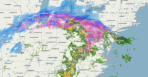
This radar image, captured at 2:45 p.m. EST Friday, Jan. 1, 2021, shows snow (blue), ice (pink and purple) and rain (yellow and red) extending from the Plains to the mid-Atlantic states. (AccuWeather) |
An area of high pressure that slid through the Northeast states on Thursday set up the shallow layer of cold air and result in a period of freezing rain and sleet for many interior locations with this storm.
"Another zone where ice may linger for an extended period is over part of the Connecticut River Valley and the Berkshires from northern Connecticut to western Massachusetts and southern portions of Vermont and New Hampshire," added AccuWeather Meteorologist Tyler Roys.
Even in the northern and western suburbs of Philadelphia and New York City, a few hours of freezing temperatures can be enough to allow a bit of ice at the onset of the storm during Friday afternoon and evening and the same around Boston Friday night. Around Pittsburgh, temperatures near the freezing mark can result in icy conditions in the city for a time Friday morning.
At this point, a major, debilitating ice storm is not expected for the majority of the region, but as general good practice with any winter storm that has the potential to cut power for a time, it may be advantageous to locate flashlights, check batteries and have cellphones charged should the power go out. During these types of weather events, AccuWeather forecasters always remind people to avoid opening the freezer and to place some non-frozen perishable items in a cooler with ice for several hours, especially outdoors where temperatures will be substantially lower than indoors.
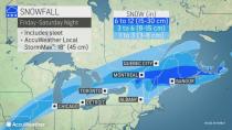
"Farther to the north, toward the St. Lawrence Valley and across northern New England in general, the layer of the cold air will be deep enough to allow snow to be the primary form of precipitation, rather than ice or rain," according to AccuWeather Senior Meteorologist Dave Bowers.
"Several inches of snow are expected to fall on northern New York state and the northern parts of Vermont, New Hampshire and Maine before any mixing of sleet occurs with the storm from late Friday night to Saturday," Bowers said.
 |
From 6-12 inches of snow is forecast to fall from northern Vermont to northwestern Maine, where cold air will hang on the longest. An AccuWeather Local StormMax™ of 18 inches is anticipated over the higher elevations in this area with the bulk of the storm occurring from Friday night to Saturday morning.
 |
Conditions are forecast to improve from southwest to northeast during the day Saturday in the Northeast with the storm leaving New England last, as is often the case.
In the Northeast, the arrival of the storm will be delayed until the daylight hours on New Year's Day, rather than 12 hours earlier during New Year's Eve, which may make the difference between this weather event being a nuisance versus a heavy buildup of hazardous ice.
The forecast arrival of the storm has been slowed down considerably since this past weekend, and that change has to do with the challenge of timing of storms that are ejected from the Southwestern states. Storms tend to break up and then regenerate crossing the Rockies, and the speed of this process can affect the arrival of precipitation thousands of miles farther to the east. Often, storms moving out from this zone have to wait for a disturbance at the jet stream level to give them a push or kick.
Since that process was finally beginning on Wednesday, a more accurate timetable of the arrival of precipitation should result moving forward with the storm.
The slow forward speed and delayed arrival of precipitation allowed outdoor televised New Year's Eve events, such as in Times Square in New York City, to carry on without any interference from Mother Nature. Dry weather is in store through at least the first few hours of 2021 in other cities such as Washington, D.C., Baltimore, Philadelphia, Boston, Pittsburgh, Buffalo, New York, Atlantic City, New Jersey, and Burlington, Vermont.
Enough rain is still forecast to fall along the coast and in inland areas to raise the risk of urban and small stream flooding. Some of the major rivers, which are still running high from the storm prior to Christmas, are likely to experience a secondary rise in water levels, but they will generally remain below that which occurred last weekend.
Anytime milder and moist air flows over top a shallow layer of cold air, cold ground or snow cover, there is the risk of fog forming and becoming locally dense. Fog may be an additional hazard for motorists and could lead to airline delays at the smaller airports as well as the major hubs from Friday to Saturday.
Keep checking back on AccuWeather.com and stay tuned to the AccuWeather Network on DirecTV, Frontier and Verizon Fios.
